Total Eclipse
동상Bronze작은 다중 그래픽과 인쇄 기법이 하나의 표현으로 결합되는 사례를 보여 줍니다.It shows how small multiples and print finishing can work together as one encoding.
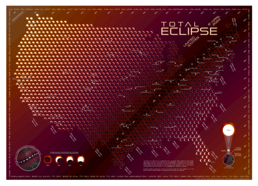
Total Eclipse는 Kenneth Field가 2024년 4월 8일 미국에서 관측된 개기일식을 주제로 만든 지도입니다. 일식의 중심 경로와 최대 식분 시각을 보여 주는 기존 지도와 달리, 미국 전역 1,500곳 이상에서 맑은 하늘을 가정할 때 실제로 어떻게 보일지를 그립니다.
Total Eclipse is a map by Kenneth Field about the total eclipse seen across parts of the United States on April 8, 2024. Where most eclipse maps show the path of totality and peak times, this one shows what viewers at more than 1,500 locations would have seen under cloud-free skies.
격자로 배열한 작은 다중 그래픽(small multiples)이 가장 어두운 순간 해와 달이 겹치는 모습을 지점마다 보여 주고, 색은 중심 경로에 가까워질수록 밝은 곳에서 어두운 곳으로 바뀌는 빛의 경험을 흉내 냅니다. 인쇄 석판화에는 중심 경로를 강조하는 부분 광택 코팅과 보이는 태양 면적을 나타내는 금박이 쓰였고, 보는 각도에 따라 지도가 빛나는 매체 특성까지 설계에 포함했습니다.
Gridded small-multiple graphics show the sun and moon at the moment of greatest overlap for each location, and color shifts from light to dark toward the path of totality. The lithograph adds spot gloss over the path and gold foil for the visible part of the sun, so the map shimmers as the viewing angle changes. It is worth studying for how print technique becomes part of the encoding.
제작Credits
Kenneth Field