Spain lives in flats: why we have built our cities vertically
동상Bronze작은 사례에서 큰 현상으로 나아가는 스크롤 구조와 대용량 지리 데이터 처리를 함께 배울 수 있는 사례입니다.It shows how a small-to-large scrolling story and heavy geospatial data processing can work together.
elDiario.es의 Raúl Sánchez와 Analía Plaza가 만든 데이터 저널리즘 프로젝트입니다. 스페인 전역 1,200만 채가 넘는 건물의 외곽선 자료를 바탕으로, 스페인 도시가 왜 이렇게 높고 밀집하게 지어졌는지를 묻습니다. 스페인 사람 셋 중 둘이 공동주택에 산다는 사실이 이야기의 출발점입니다.
This data journalism project by Raúl Sánchez and Analía Plaza of elDiario.es draws on the footprints of more than 12 million buildings across Spain. It asks why Spanish cities were built so tall and dense, starting from the fact that two of every three Spaniards live in flats.
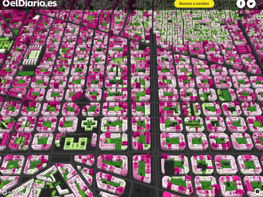
모든 건물의 높이를 3D 지도로 보여 주며, 독자는 자기 동네 건물의 높이를 직접 탐색할 수 있습니다. 스크롤을 따라 A Coruña의 건물 하나에서 출발해 스페인 전체의 수직 도시화로 확장되고, 시대별 도시 모델이 그래픽과 함께 설명됩니다. 200GB가 넘는 지적 자료를 R로 수집해 정리하고 모든 기기에서 지도가 돌아가도록 압축한 과정도 배울 만합니다.
A 3D map lets readers explore the height of buildings in their own areas, and a scrolling narrative moves from a single building in A Coruña to the nationwide phenomenon of vertical urbanism, with graphics explaining each decade's urban model. The data work is also instructive: over 200GB of cadastral files were collected in R, cleaned, and compressed so the map runs on any device.
제작Credits
Raúl Sánchez, data journalist @raulsanchezglez
Analía Plaza, reporter @lalalalia