Flowmap.blue
동상Bronze잘 고른 하나의 차트 형식이 다양한 이동 데이터를 위한 재사용 가능한 도구가 되는 과정을 보여 주는 좋은 예입니다.A good example of how one well-chosen chart form can be packaged as a reusable tool for many kinds of movement data.
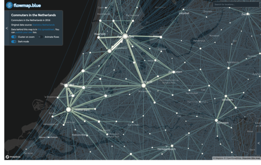
Flowmap.blue는 일리야 보이안딘(Ilya Boyandin)이 만든 무료 오픈소스 플로맵 제작 도구입니다. 지리적 장소 사이를 오간 이동량을 집계해 보여 주며, 통근, 자전거와 스쿠터 공유, 이주, 무역, 화물 운송, 역학, 철새 이동 등 다양한 주제에 쓰이고 있습니다.
Flowmap.blue is a free, open source tool created by Ilya Boyandin for drawing flow maps. It shows aggregated counts of movement between geographic locations, and people around the world have applied it to topics such as commuting, bike and scooter sharing, migration, trade, freight, epidemiology and bird migration.
이 도구는 출발지와 도착지 데이터를 플로맵으로 바꿔, 사용자가 자신의 데이터로 장소 간 이동이 어떻게 이어지는지 확인할 수 있게 합니다. 도시 교통에서 어업, 하수도 시스템까지 활용 범위가 넓어, 하나의 이야기가 아니라 범용 시각화 도구의 사례로 살펴볼 만합니다.
The tool turns origin-destination data into flow maps, so a user can bring their own dataset and see how movement connects places. Its range of uses, from urban transport to fishery and sewer systems, makes it a useful case of a general-purpose visualization tool rather than a single story.
제작Credits
Ilya Boyandin