Cartographers Of North Korea
금상Gold데이터 분석과 인터뷰를 함께 써서 지도 뒤에 있는 사람들에 대한 질문에 답하는 방식을 보여줍니다.It shows how data analysis and interviews together can answer a question about people behind a map.
MIT의 원영 소(Wonyoung So)는 오픈스트리트맵(OpenStreetMap)에서 누가, 왜 북한을 지도로 그리는지 연구합니다. 정부가 주민의 인터넷 접근을 통제하는 지역을 자원봉사 '안락의자 매퍼'들이 어떻게 지도화하는지 살펴봅니다.
Wonyoung So of the Massachusetts Institute of Technology studies who maps North Korea on OpenStreetMap and why. The project looks at how volunteer "armchair mappers" chart a territory where the government restricts citizens' internet access.
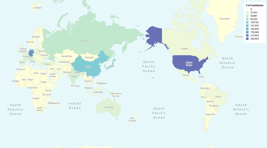
이 작업은 북한에 대한 오픈스트리트맵 데이터 분석과 889명의 기여자와 주고받은 구조화된 서신을 바탕으로 합니다. 기여자들이 어떤 도구와 방법으로 정보를 얻고 이 나라를 표현하는지, 그리고 동기는 무엇인지 묻습니다. 데이터와 인터뷰를 결합해 지도 제작의 정치성을 탐구하는 연구 중심 프로젝트로서 공부할 가치가 있습니다.
The work is built on an analysis of OpenStreetMap data for North Korea and structured correspondence with 889 contributors. It asks which tools and methods they use to find information and represent the country, and what motivates them. It is worth studying as a research-driven project that combines data and interviews to examine the politics of mapping.
제작Credits
Wonyoung So